The Elliot Lake Uranium Project is in south-central Ontario and covers 41 multi-cell mining claims covering 180 km² in the prolific Elliot Lake Uranium district, along strike from historic major uranium producing mines.
The Project is accessible by road from Toronto (a ~6 hour drive). Year-round access and proximity to existing infrastructure provide logistical advantages.
A field reconnaissance program, including mapping, sampling and drill hole siting, has commenced at Elliot Lake, where the Company is targeting conglomerate hosted uranium mineralisation.
The prolific Elliot Lake uranium district produced 362 Mlbs U₃O₈ @ 0.1060% (1,060 ppm) U₃O₈ from 13 underground mines active between 1955 and 1996, within an area of c. 15 × 15 km.
The uranium mineralisation at Elliot Lake is hosted by stratabound
conglomerate beds, which are relatively continuous and geologically predictable. The mineralised beds can be up to 19.5 km long, 8.0 km wide and 4 m thick.
Overview
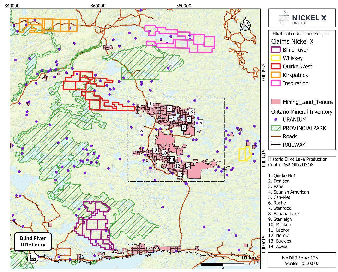
The Elliot Lake Uranium Project (Figures 1 and 2) consists of 5 sub-projects comprising a total of 41 multi-cell mining claims for 180 km2
NickelX is targeting conglomerate-hosted uranium and rare earth element (REE) mineralisation along the underexplored interpreted extensions to the historic, major uranium mining centre at Elliot Lake.
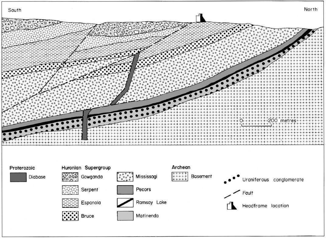
The targeted uranium mineralisation style is stratabound and consequently relatively continuous and predictable. The known deposits typically have excellent lateral and down-dip grade and thickness continuity, providing potential for large-scale deposits (Figure 3).
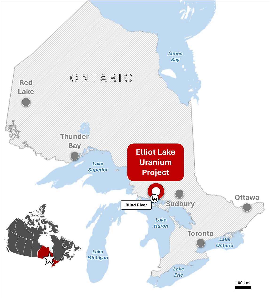
The Project area is considered to have excellent year-round access, is close to infrastructure and service centres, electrical and water supplies and the world’s largest commercial uranium refinery at Blind River (Figure 1), operated by uranium major Cameco Corporation.
Figure 2: Map of the Elliot Lake Uranium Project and surrounds, also showing the historic Elliot Lake uranium production centre where 362 Mlbs U₃O₈ were mined in the 1950s to 1990s.
Figure 3: Schematic cross section of the New Quirke uranium mine at Elliot Lake [not owned by Nickelx] – nearby to the Elliot Lake projects held by NickelX. This section highlights the continuous and sedimentary nature of the mineralisation at Eliot Lake
Figure 1: Location of the Elliot Lake Uranium Project in south-central Ontario, Canada.
Exploration Targets
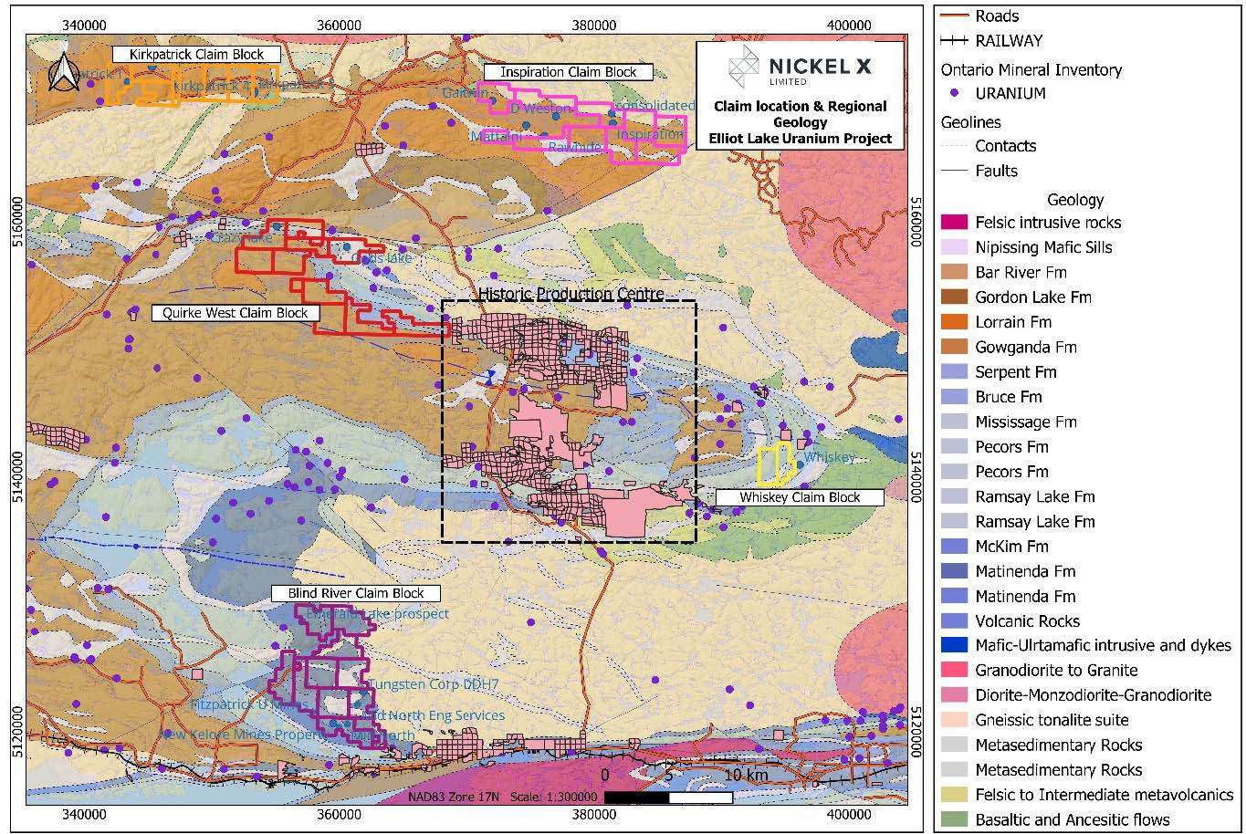
An initial desktop study (see ASX announcement dated February 21st, 2024) identified several priority targets, all of which are located within broad domains of interpreted and demonstrated uranium prospectivity (Figure 4):
Crazy Lake-Gods Lake Trend (Quirke West claim block): This trend, along strike from the large historic Quirke No 1 mine c. 14 km to the E, covers highly prospective geology, including the extremely well endowed Matinenda Formation (Elliot Lake Group). Historic drilling of this trend has been minimal with only seven drillholes completed with the claim block. The adjacent Flack Lake thrust fault and subsidiary fault structures may have served as pathways for hydrothermal fluids, aiding in overprinting and or enhancing any existing uranium mineralisation.
Gaitwin-Inspiration Trend (Inspiration claim block): This trend, potentially developed within the Lorrain Formation (the main uranium host of the Cobalt Group) and marked by the Gaitwin, Mattaini, D. Weston, Rawhide, Consolidated Golden and Inspiration uranium occurrences. Structurally, this trend is interpreted to be developed along an E-W-striking fold limb that is cut by NE-SW-striking cross faults. Drilling has been very limited in this area with only 10+ holes completed over a 17 by 3 km area. Most of these holes were drilled at the Mattaini and Inspiration uranium occurrences.
Iron Lake Trend (Kirkpatrick claim block): A potential repetition of the Gaitwin-Mattaini- Rawhide-Inspiration Trend to the E.
Quirke Fold Hinge Trend (Whiskey claim block): Requires a more detailed assessment of previous drilling and available geophysical data to better constrain the local geology and identify clear targets. This work is ongoing.
Figure 4. Map of the Elliot Lake Uranium Project and regional geology, also showing the historic Elliot Lake uranium production centre.